Siege of Louisbourg

During the 1758 siege of the fortress of Louisbourg (in what is today Nova Scotia), five French ships were sunk in the harbour by the British. Twenty cannons from the sunken ships were raised in 1899. Two of these cannons were purchased by students at the University of Toronto for use as historic monuments: one cannon was purchased by the Arts Class of 1901 and the other by the Students' Engineering Society. Both cannons were restored in 1993-4.

This French mortar was used in the Siege of Louisbourg in 1758. Displayed in the Canadian War Museum, Ottawa.

General Wolfe at the siege of Louisbourg, 1758

British burning of the warship Prudent and capturing of the warship Bienfaisant during the siege of Louisbourg 1758.label QS:Len,"British burning of the warship Prudent and capturing of the warship Bienfaisant during the siege of Louisbourg 1758."label QS:Lde,"Briten verbrennen das Kriegsschiff Prudent und erorbern das Kriegsschiff Bienfisant während der Belagerung von Louisbourg 1758."
Stokes 1758-B-92 From Scenographia Americana, 1768. Print also published in London by Robert Sayer, Thomas Jefferys, Carington Bowles and Henry Parker. Print contains 6 references in lower margin. Deák 108
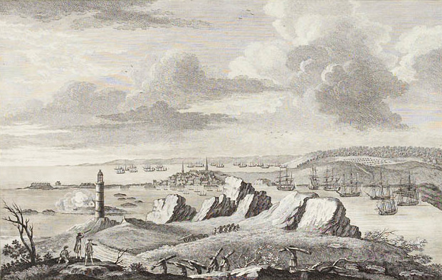
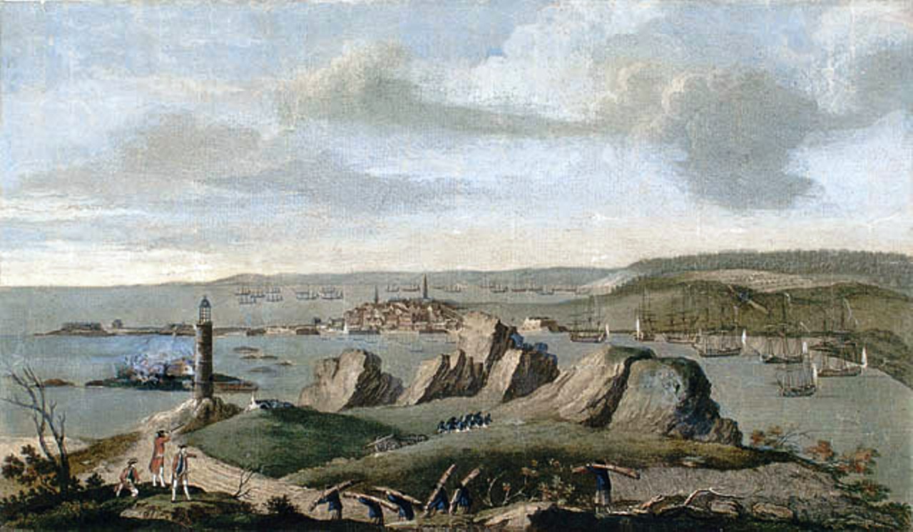
A View of Louisburg in North America, November 11, 1762. This image depicts the city of Louisburg in the background, Gabarus Bay, the English Camp, the French Fleet, the Island Battery and the Lighthouse can beseen on the left. Captain Ince. Thomas Jefferys. Peter Winkworth Collection. Library and Archives Canada, e000943143

* Printmakers include Henry Bryan Hall, Jacobus Houbraken, James McArdell, Thomas Phillibrowne & William Wellstood. Title from Calendar of the Emmet Collection. EM1772
* Printmakers include Henry Bryan Hall, Jacobus Houbraken, James McArdell, Thomas Phillibrowne & William Wellstood. Title from Calendar of the Emmet Collection. EM1772
![A View of Louisburg in North America, taken near the Light House when that City was besieged in 1758.
View of the siege of Louisbourg on Cape Breton Island. Built environment includes fortifications, dwellings, churches, ships, and lighthouse. In the foreground men carry bundles of wood and pull a cannon while others look through telescopes. Items in the image are numbered for identification at the bottom of the image.
Place image published:[London]Image publisher:Thos. Jefferys, at Charing CrossImage date:1762 Novr. 11](https://upload.wikimedia.org/wikipedia/commons/4/4a/A_View_of_Louisburg_in_North_America%2C_taken_near_the_Light_House_when_that_City_was_besieged_in_1758_%28JCB%29.jpg)
A View of Louisburg in North America, taken near the Light House when that City was besieged in 1758. View of the siege of Louisbourg on Cape Breton Island. Built environment includes fortifications, dwellings, churches, ships, and lighthouse. In the foreground men carry bundles of wood and pull a cannon while others look through telescopes. Items in the image are numbered for identification at the bottom of the image. Place image published:[London]Image publisher:Thos. Jefferys, at Charing CrossImage date:1762 Novr. 11
![A View of Louisburg in North America, taken near the Light House when that City was besieged in 1758.
View of the siege of Louisbourg on Cape Breton Island. Built environment includes fortifications, dwellings, churches, ships, and lighthouse. In the foreground men carry bundles of wood and pull a cannon while others look through telescopes. Items in the image are numbered for identification at the bottom of the image.
Place image published:[London]Image publisher:Thos. Jefferys, at Charing CrossImage date:1762 Novr. 11](https://upload.wikimedia.org/wikipedia/commons/5/5a/A_View_of_Louisburg_in_North_America%2C_taken_near_the_Light_House_when_that_City_was_besieged_in_1758_%28NAM%29.jpg)
A View of Louisburg in North America, taken near the Light House when that City was besieged in 1758. View of the siege of Louisbourg on Cape Breton Island. Built environment includes fortifications, dwellings, churches, ships, and lighthouse. In the foreground men carry bundles of wood and pull a cannon while others look through telescopes. Items in the image are numbered for identification at the bottom of the image. Place image published:[London]Image publisher:Thos. Jefferys, at Charing CrossImage date:1762 Novr. 11
A View of Louisburg in North America, taken near the Light House when that City was besieged in 1758. View of the siege of Louisbourg on Cape Breton Island. Built environment includes fortifications, dwellings, churches, ships, and lighthouse. In the foreground men carry bundles of wood and pull a cannon while others look through telescopes. Items in the image are numbered for identification at the bottom of the image. Place image published:[London]Image publisher:Thos. Jefferys, at Charing CrossImage date:1762 Novr. 11

* Printmakers include Asher B. Durand, Henry Bryan Hall, Albert Rosenthal and Max Rosenthal. Draughtsmen include David McNeely Stauffer. Title from Calendar of Emmet Collection. Includes some photomechanical reproductions. Citation/reference : EM322
* Printmakers include Asher B. Durand, Henry Bryan Hall, Albert Rosenthal and Max Rosenthal. Draughtsmen include David McNeely Stauffer. Title from Calendar of Emmet Collection. Includes some photomechanical reproductions. Citation/reference : EM322

A View of Louisburg in North America, November 11, 1762. Lithograph This image depicts the city of Louisburg in the background, Gabarus Bay, the English Camp, the French Fleet, the Island Battery and the Lighthouse can beseen on the left. Captain Ince. Thomas Jefferys. Peter Winkworth Collection. Library and Archives Canada, e000943143
A View of Louisbourg when that city was besieged in 1758

Engraving made after a painting by Richard Paton. Capture of the French ship Bienfaisant (64 guns), during the siege of Louisbourg in 1758.

Engraving made after a painting by Richard Paton. Burning of the French ship Prudent (74 guns), during the siege of Louisbourg in 1758.
Caption title At head of title: [Published under the auspices of the Literary and Historical Society of Quebec.] "The narrative of the campaign of Louisbourg forms one of the three manuscripts ascribed to the Chevalier Johnstone"--p.[2] Filmed from a copy of the original publication held by the Législature du Québec, Québec 43 Subjects:

Engraving made by Canot after a painting by Richard Paton. Burning of the French ship Prudent (74 guns) and capture Bienfaisant (64 guns), during the siege of Louisbourg in 1758.
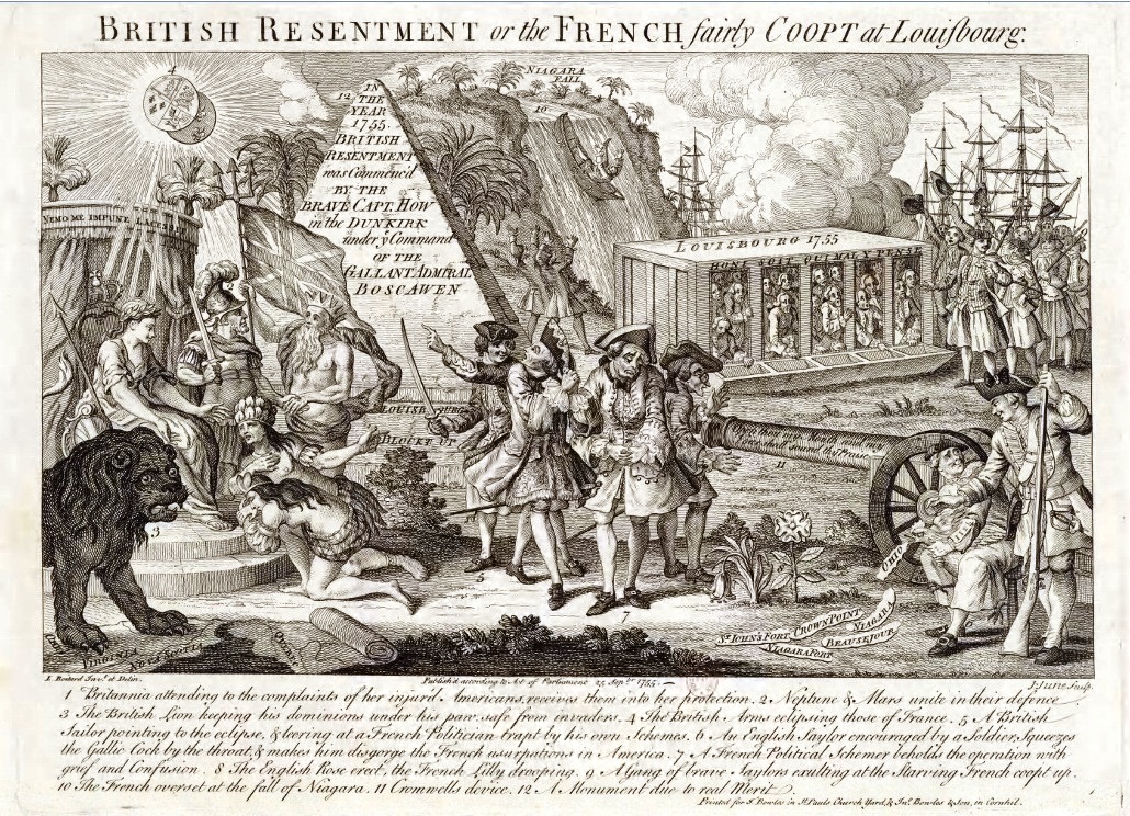
English propaganda against Louisbourg and French Canada in 1755 : " British Resentment or the French fairly Coopt at Louisbourg ". Printed for T. Bowles in S.t Pauls Church yard and In.o Bowles and son, in Cornhil.

Cannon from the French flagship Le Prudent, captured and burned at Louisbourg, 1758, currently at the Battlefield Park, Quebec City
* Volume numbers given here refer to the original volume numbers of the publication, not of Lossing's publication. Printmakers include Bichebois, P. Canot, H.B. Hall, John Hill, S.V. Hunt, A.H. Ritchie. Title from title page of extra-illustrated volume. EM4435 "Drawn on the spot by Capt. Ince of the 35t. Regt. Engraved by P. Canot."

Peregrine Lascelles, Whitby Museum, North Yorkshire.General Peregrine Lascelles (1685–1772) (Q119735956).

One of two cannons flanking the entrance to the Whitney Block on Queen's Park Circle in Toronto, Ontario, Canada. The cannons were on the French naval ship Prudent, captured and burned by the British in June 1758 during the siege of Louisbourg. Twenty cannons, from Prudent and other French ships sunk during the siege, were raised in 1899, two of which were acquired by the Government of Ontario.
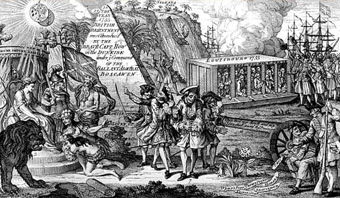
Siege_of_Louisbourg_allegory.
Historical Overview
British capture of the "Fortress of the North"; opened the route to the St. Lawrence River.
Quick Facts
Kingdom of Great Britain
- Commander: Jeffrey Amherst
- Strength: ca. 27.000
- Casualties: ca. 500
Kingdom of France
- Commander: Chevalier de Drucour
- Strength: ca. 7.000
- Casualties: ca. 6.000 (Gefangen)
Strategic Context
Strategic elimination of the strongest French fortress in the Atlantic to control the sea route to Quebec.
Conflict / War
Seven Years' War
Historical Locations
Interactive map requires third-party cookie consent.